
Severe storms have set a fast pace for the first half of 2024. Will exposure growth and climate change combine to produce another year of high losses from convective storms?
For the United States, summer isn't even in full swing yet, and it's already been an extremely active year for severe convective storms.1 To date, 2024 has the second-highest number of tornado reports (1,264) of any year in the past 15 years. We've also seen very high numbers of hailstorms (4,108 — the fifth most active year) and damaging windstorms (8,978 — the second most). Fortunately, this year still lags well behind the pace set in 2011, which remains the worst year on record for all three perils across the U.S.
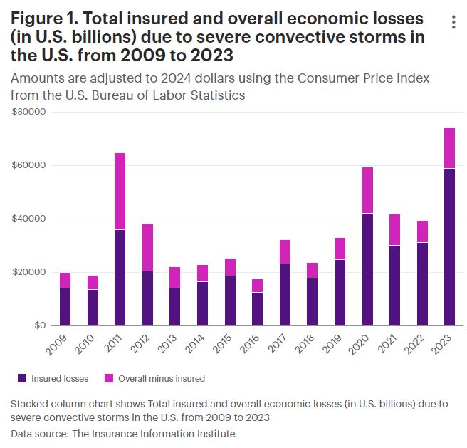
Total storm counts for the entire country are an imperfect proxy for economic or insured losses. In 2011 and again in 2023, high numbers of wind and hailstorms added up to the worst years for direct damages in recent memory (Figure 1). On the other hand, although 2020 was a typical year with respect to tornado and windstorm numbers (and with a lower-than-average number of hailstorms), economic and insured losses were still high. But because most damaging storms happen in summer, our early start to the severe weather season may portend yet another costly year with high damages from convective storms.
Major storms so far in 2024
This year's strongest storms have been associated with tornado "outbreaks," which occur when multiple tornadoes spawn from the same large-scale weather pattern over one or more days. From April 26 to 28, severe weather over the Southern and High Plains generated more than 140 tornadoes, including a violent (intensity EF4) tornado that destroyed a Dollar Tree distribution warehouse in Marietta, Oklahoma. Another large outbreak from May 6 to 10 saw more than 160 tornadoes hit Oklahoma, Kansas, Tennessee, Alabama, Georgia and Michigan. That system was so destructive that several National Weather Service offices took the unusual step to issue tornado "emergencies" (situations where a severe threat to human life is imminent or ongoing). Finally, from May 19 to 27 the Midwest experienced an extended period of tornadic activity that culminated with a large, violent EF4 tornado that devastated Greenfield, Iowa, and killed at least five people.
But wind speed is not the only factor that determines if extreme weather will cause high damages. The derecho that struck the Gulf Coast on May 16 and 17 had winds that peaked at just over 100 miles per hour (160 kilometers per hour), equivalent to a moderate (EF1) tornado. But because this system passed directly through downtown Houston, it produced widespread and significant damage. Described as the most destructive wind event to affect the city in a generation, the derecho blew out windows of many high-rise windows, damaged electrical transmission lines and caused the deaths of at least eight people.
The subtle hand of climate change?
Based on our understanding of how severe convective storms form and grow, we might expect a warmer world to also be a stormier one. Climate model simulations suggest, under various warming scenarios, the U.S. will experience stronger updrafts, which would lead to more favorable environments for the genesis of severe thunderstorms.2 But in its latest report, the Intergovernmental Panel on Climate Change states there is low confidence in past trends in hail and winds and tornado activity. Why is it so hard to know whether severe convective storms have become stronger or more frequent?
In order to produce a thunderstorm, the atmosphere needs to have three main ingredients:
- sufficient moisture,
- strong updraft, and
- a strong change of wind speed or direction with height.
Part of the reason we struggle to understand long term trends in tornadoes, hailstorms and damaging windstorms is because the most severe storms are rare. More tornadoes affect the U.S. than any other country worldwide. But since 1950, only 59 tornadoes have been formally rated as catastrophic (EF5) — fewer than one per year. It's also been more than a decade since the most recent EF5 event, the 2013 Moore tornado that destroyed more than 1,100 homes in Oklahoma. It's fortunate the most violent storms are few and far between, but their low numbers make it challenging to apply standard statistical approaches to determine whether or not they are becoming more common.
In order to tease out subtle but important changes in the risk of severe convective storms, WTW has partnered with Columbia University's Department of Applied Physics and Applied Mathematics to investigate current and future trends in tornado behavior. In a recent study published by the Monthly Weather Review, our partners Dr. Kelsey Malloy and Prof. Michael Tippett developed a new risk index to calculate the probability of a tornado outbreak based on large-scale weather patterns.3 By combining their index with on-the-ground storm reports, they were able to demonstrate that, in parts of Alabama, Georgia, Missouri and Mississippi, today tornado outbreaks are more than twice as frequent as they were in the early 1980s.
Tornado risk solutions from WTW
By leveraging the latest scientific evidence in our risk models and risk consulting, clients of WTW's Climate Practice benefit from advanced, quantitative insight able to underpin a smarter, forward-looking approach to managing tornado risk — both to their own facilities and across the value chain. Starting with an initial assessment of tornado exposure using Global Peril Diagnostic, WTW's cross-disciplinary solutions — spanning risk engineering, climate science and Enterprise Risk Management — are designed to provide clients the insight necessary to inform risk management decisions that enhance their resilience.
Implications for risk managers
Risk assessment and mitigation
Perform comprehensive assessments of exposure to severe weather events, particularly tornadoes, hail and straight-line wind. Use advanced risk models and the latest scientific discoveries to inform mitigation strategies and enhance resilience.
Climate change research
Incorporate climate change research findings into risk management. Update estimates of the frequency and severity of severe thunderstorms to improve planning, preparedness and risk management.
Risk management and transfer
Partner with natural catastrophe risk specialists to develop solutions for managing and transferring the increasing risks from severe weather in the U.S. and elsewhere.
Footnotes
1 NOAA Storm Prediction Center. Severe Weather Maps, Graphics, and Data Page. (2024).
2 Brooks, H.E. Severe thunderstorms and climate change. Atmospheric Research 123, 129-138 (2013).
3 Malloy, K, Tippett, M.E. A stochastic statistical model for U.S. outbreak-level tornado occurrence based on the large-scale environment. Monthly Weather Review 152 (5), 1141-1161.
The content of this article is intended to provide a general guide to the subject matter. Specialist advice should be sought about your specific circumstances.