By: Mr. Kojo Bentsi-Enchill
Miss. Seyram Dzikunu
Miss. Eyitemi Adetugbo
In this newsletter, we review the decision of the International Tribunal for the Law of the Sea ("ITLOS") in relation to the dispute concerning the delamination of the maritime boundary between Ghana and Côte d'Ivoire in the Atlantic Ocean. Côte d'Ivoire had accused Ghana of overstepping its maritime boundary in the exploration of oil in portions of the Tano Basin in the Western Region of Ghana. However the ITLOS Special Chamber in a unanimous decision on Saturday 23rd September 2017 held that, there had not been any violation on the part of Ghana on Côte d'Ivoire's maritime boundary. This newsletter will review the implications of this decision for companies engaged in petroleum activities within the disputed area.
A. Background
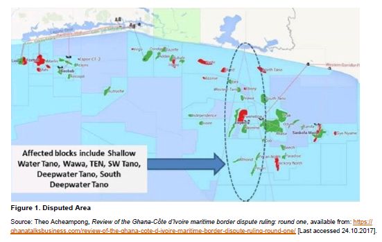
The area in dispute between Ghana and Côte d'Ivoire lies at the centre of the Tano Basin, a proven petroleumrich offshore basin. Both countries were claiming ownership of the territory, which energy experts estimated to hold two billion barrels of oil reserves and 1.2 trillion cubic feet of natural gas.
A year after Ghana discovered oil in commercial quantities, Côte d'Ivoire staked a rival claim to parts of the area covered by the discovery. Ghana and Côte d'Ivoire (the "Parties") attempted to settle the matter by
amicable negotiations but to no avail. On 3 December 2014, the Parties entered into a Special Agreement to submit the maritime border dispute to a Special Chamber of the International Tribunal for the Law of the Sea (the "Special Chamber"). On 27 February 2015, Côte d'Ivoire filed a Request for the Prescription of Provisional Measures to the Special Chamber, requesting the Special Chamber to grant temporary provisional measures for Ghana to suspend all oil exploration and production activities in the disputed area pending the resolution of the full case in late 2017. On 25th April 2015, the Special Chamber granted this request and placed a moratorium on new drilling activities. This meant that operators such as Tullow, Kosmos and Hess were forced, for example, to stop new drilling in the disputed area. On Saturday 23rd September 2017, the Special Chamber rejected Côte d'Ivoire's claim that Ghana's exploration activities in the disputed basin were infringing on its sovereign rights or maritime boundary. Justice Boualem Bouguetaia, President of the Special Chamber in reading the judgment, accepted Ghana's argument of adoption of the equidistance method of delineation of the maritime boundary.
B. The judgement
In a unanimous decision, the Special Chamber held that Côte d'Ivoire did not provide a strong argument for its claims. The Special Chamber mostly ruled in Ghana's favour, on the arguments put forward by Côte d'Ivoire. In its judgement, the Special Chamber addressed the points outlined below.
Jurisdiction of the Special Chamber
There was no disagreement between the Parties regarding the jurisdiction of the Special Chamber in this case. Nevertheless, the Special Chamber held that it had the jurisdiction to delimit the maritime boundary between the Parties in the territorial sea, the exclusive economic zone ("EEZ") and on the continental shelf, both within and beyond 200nm.1 The Special Chamber also held that it had the jurisdiction to decide on the claim of Côte d'Ivoire against Ghana on the alleged international responsibility of Ghana.2 This was on the basis that both Parties were parties to the United Nations Convention on the Law of the Sea (the "Convention") which gives the Special Chamber jurisdiction over any dispute concerning interpretation or application of the Convention.3
Tacit agreement
Ghana asked the Special Chamber to declare that the Parties mutually recognised, agreed and applied an equidistance based maritime boundary in the territorial sea, EEZ and continental shelf within 200nm during various bilateral exchanges. Ghana referred to this as the "customary equidistance boundary". Ghana wanted the Special Chamber to hold that Côte d'Ivoire was, in accordance with international law and by reason of its representations upon which Ghana had placed reliance, estopped from objecting to the agreed maritime boundary.4 Côte d'Ivoire rejected this argument.
The Special Chamber found in favour of Côte d'Ivoire and rejected Ghana's claim that Côte d'Ivoire was estopped from objecting to the customary equidistance boundary.5 Further, the Special Chamber found that Ghana did not present enough evidence to show the existence of an implicit agreement between the Parties in relation to the customary equidistance boundary.6 For example, the limits of the oil concessions of the Parties was not sufficient to infer the existence of the maritime boundary.7 Further, the fact that the Parties engaged in bilateral exchanges in an attempt to delimit their maritime boundary showed that there was no tacit agreement.8
Equidistance vs bisector method of delineation
Ghana argued that the Special Chamber should use the equidistance/relevant circumstances methodology for maritime delineation. This is the concept that a nation's maritime boundary should conform to a median line equidistant from the shores of neighbouring nation states. Further, Ghana argued that the existing customary equidistant line, and the oil activities of both countries be considered as a special circumstance to adjust any new line in Ghana's favour.
Côte d'Ivoire however argued that the angle bisector line method of delimitation was the most geometrical approach. This method is based on the general direction of the coastal geography of two countries with adjacent coasts. This would result in a 168.7 degrees azimuth line9 extending to the outer limit of the Ivorian continental shelf. Côte d'Ivoire also argued that if the Special Chamber were to adopt the equidistance/relevant circumstances method, certain geography related special circumstances warranted an adjustment of the resulting equidistance in their favour.10 Côte d'Ivoire suggested that some geography related special circumstances were that both countries had unstable coastlines11 and that the base points used for the construction of the provisional equidistance line were all located on Jomoro. Being only one percent of Ghana's territory, Côte d'Ivoire argued that Jomoro is an incursion into Ivorian territory that takes the form of a narrow strip of land blocking the seaward projection of part of the Ivorian land mass.12
Critically, the Special Chamber accepted Ghana's argument and adopted the equidistance method of delimitation of the maritime boundary, rejecting Côte d'Ivoire's angle bisector line method of delimitation.13 This was on the basis that the equidistance/relevant circumstances method would achieve the most equitable result and there were no compelling reasons making it impossible or inappropriate to draw a provisional equidistance line.14 The Special Chamber also rejected both Parties' arguments that certain special circumstances warranted the adjustment of the resulting line in either Party's favour.15 The Special Chamber noted that Jomoro is part of Ghana's territory and could not be ignored in determining Ghana's maritime entitlements. Significantly, the Special Chamber held that "a de facto line related to oil practice of the disputing coastal States cannot per se be a relevant circumstance" in maritime delimitation.16
Starting and turning points
The Parties agreed that the land boundary and starting point for the maritime boundary was at Boundary Pillar 55 (BP 55). However, the Parties disagreed on the points along their coasts from which the boundary was to be measured, the so called base points.
Significantly, the Special Chamber plotted new geographic coordinates for BP 55, which it referred to as BP 55+, on the basis that the geographic coordinates used by both Ghana and Côte d'Ivoire were inaccurate. BP 55+ was held to be at 05° 05' 23.2" N, 03° 06' 21.2'' W.17 Using the equidistance/relevant circumstances methodology, the Special Chamber delineated the maritime boundary, starting on land from BP 55+, extending into the sea, to 200 nm and beyond.18 The resulting boundary includes six turning/base points at which the direction of the line changes and which are connected by geodetic lines.19
Violation of Côte d'Ivoire's sovereign rights
Côte d'Ivoire urged the Special Chamber to hold that Ghana's unilateral petroleum activities in the disputed maritime area constituted a violation of the exclusive sovereign rights of Côte d'Ivoire over its continental shelf. On this basis Côte d'Ivoire asked the Special Chamber to invite the Parties to carry out negotiations to agree on terms of compensation due to Côte d'Ivoire. Failing successful negotiations within 6 months, the Special Chamber was to determine the terms of compensation.
The Special Chamber held that Ghana did not violate the sovereign rights of Côte d'Ivoire20 and therefore no compensation was payable.21
Obligation to negotiate in good faith
Côte d'Ivoire argued that Ghana's unilateral activities in the disputed area and its inflexibility in negotiations constituted a violation of Ghana's obligation to negotiate in good faith, as well as its obligation not to jeopardize or hamper the conclusion of an agreement. Ghana called on the Special Chamber to reject these claims.
The Special Chamber found in favour of Ghana and held that Côte d'Ivoire failed to prove bad faith on the part of Ghana during negotiations. As such, it held that Ghana negotiated in good faith and did not jeopardize or hamper the conclusion of an agreement.22
Violation of provisional measures
An order of the Special Chamber of 25 April 2015, prescribed for a moratorium on new petroleum activities and for the Parties to cooperate to that end (the "Order"). Côte d'Ivoire argued that although there was no drilling of new wells, Ghana carried out new drilling activities within existing wells thus violating the Order as Ghana should have abandoned all drilling activities. Ghana called on the Special Chamber to reject such a claim. Ghana argued that it complied faithfully with the Order as there was no drilling of any new wells. The only activity undertaken by operators was work carried out on wells which had already been drilled, which was necessary for production and maintenance of the oil deposits, permitted under the Order.
The Special Chamber agreed with Ghana and held that Ghana did not violate the provisional measures prescribed by the Order. Ghana did not violate the Order by continuing existing drilling activities in developed oilfields as these were ongoing activities as opposed to new drilling activities.23
C. Implications of the decision
Uninterrupted continuation of Ghana's petroleum operations
This decision permits Ghana to continue with its petroleum operations in the Tano Basin. The initial moratorium which prevented Ghana from drilling more wells in the disputed area has been lifted by the ruling. Petroleum companies that have entered into Petroleum Agreements with the Government of Ghana with respect to the Tano Basin that have been unable to carry out their contractual duties as a result of the moratorium can move to site and comply with their amended minimum work obligations or relinquish their interests. For example, this decision will allow Tullow to rigorously increase its production activities, while Hess can now proceed to develop the Deep Water Tano Cape Three Points fields. Petroleum service providers can also resume exploration and drilling activities. This will in effect have positive social impacts for Ghana in light of the local content requirements for companies engaged in petroleum activities.
Expansion of Ghana's territory
By the Special Chamber plotting new coordinates for BP 55+ and applying the equidistance method of delineation, this in effect gave Ghana more territory than it had initially argued for. According to Ghana's Energy Minister, Mr. Boakye Agyarko, Ghana has 80 square kilometres of territorial space which was not originally anticipated.24 However, Ghanaian authorities are yet to publish a map showing the new territorial limits established by the decision of the Special Chamber. In any case Ghana could potentially have more territory open for petroleum exploration activities if the Minister for Petroleum decides to exercise his power to open the new areas for petroleum activities.25 Petroleum companies already engaged in activities in the Tano Basin can take advantage of this and may seize the opportunity to enter into new or revised Petroleum Agreements with the Government of Ghana in respect of petroleum activities in this new territory. Consequently, this would also create more opportunities for petroleum service providers with the area for exploration and extraction being larger than anticipated.
Comfort for investors in certainty of delimitation
This decision is of extreme importance. ITLOS is the most competent legal body to resolve maritime disputes. The decision is binding and not open to appeal. This provides clarity and certainty of the delimitation of the maritime boundary between Ghana and Côte d'Ivoire and will create a sense of stability for prospective investors. The decision therefore provides comfort for investment attraction to the Tano Basin straddling both sides of the previously disputed border, which has lower exploration risk after discoveries by Tullow and Hess in Ghana, and Total in Côte d'Ivoire.
Uncertainties for future discoveries straddling the boundary
Given the discoveries that have been made on both sides of the previously disputed maritime boundary, there is the possibility of future discoveries that could straddle the newly established maritime boundary. Such discoveries may require joint field development and operation. The Petroleum (Exploration and Development) Act 2016 (Act 919) provides that where a petroleum discovery extends onto the territory of another country, Ghana may seek to reach agree ment with that other country on the most efficient coordination of petroleum activities in connection with accumulation and apportionment of petroleum.26 While both countries seek to reach some agreement as to how petroleum activities will be coordinated, this period of uncertainty could prove problematic for petroleum companies engaged in activities close to the new maritime boundary.
Ongoing cooperation between Ghana and Côte d'Ivoire
Finally, the decision of the Special Chamber must be seen as a victory for Ghana and Côte d'Ivoire, West Africa and for Africa as a whole. Without the Parties' cooperation and commitment to a peaceful resolution, the dispute resolution process would have been frustrated, thus creating insecurity to petroleum activities within the disputed area. Insecurity could have presented in the form of socio cultural unrest, international meddling, and rising political tensions between the Parties. The agreement by the Parties to be bound by the decision of the Special Chamber, is a step in the right direction towards peaceful coexistence which strengthens the basis for future partnerships in the upstream oil and gas sector. This provides some reassurance for petroleum operators and service providers that future disputes between the Parties can be resolved cooperatively, therefore minimising the effects on petroleum operations.


Footnotes
1. Delimitation of the maritime boundary between Ghana and Côte d'Ivoire in the Atlantic Ocean (Ghana and Côte d'Ivoire) 2017, ITLOS Case No 23 @ paras. 88 – 89.
2. Id., paras. 546 and 554.
3. Id., paras. 83 – 84.
4. Id., paras. 229 – 240.
5. Id., paras. 241 – 246.
6. Id., paras. 211– 228.
7. Id., para. 217.
8. Id., para. 221.
9. The azimuth of a line is its horizontal angle measured clockwise from geographic or true meridian.
10. Delimitation of the maritime boundary between Ghana and Côte d'Ivoire in the Atlantic Ocean (Ghana and Côte d'Ivoire) 2017, ITLOS Case No 23 @ para. 253 – 256, 270 – 276 and 291.
11. Id., para. 311 – 313.
12. Id., para. 303 – 305.
13. Id., para. 289.
14. Id., paras. 281 – 289.
15. Id., paras. 426, 434, 455, 479 and 480.
16. Id., para. 477.
17. Id., para. 356.
18. Id., paras. 400 – 401 and 540.
19. Geodetic lines are the shortest lines that can be drawn between two points on the curved surface of the earth.
20. Delimitation of the maritime boundary between Ghana and Côte d'Ivoire in the Atlantic Ocean (Ghana and Côte d'Ivoire) 2017, ITLOS Case No 23 @ para. 594.
21. Id., para. 659.
22. Id., para. 634.
23. Id., paras. 651 – 658.
24. 'ITLOS ruling: Ghana gains 80 square km more of territorial space, available from: https://www.myjoyonline.com/news/2017/September27th/itlosrulingghanagains80squarekmmoreofterritorialspace.php [Last accessed 28.09.2017] and Delimitation of the maritime boundary between Ghana and Côte d'Ivoire in the Atlantic Ocean (Ghana and Côte d'Ivoire) 2017, ITLOS Case No 23 @ para. 401.
25. Petroleum (Exploration and Development) Act 2016 (Act 919), Section 7(1).
26. Id., s. 35.
Frst published 13 November 2017.
The content of this article is intended to provide a general guide to the subject matter. Specialist advice should be sought about your specific circumstances.